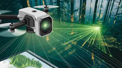
LiDAR (Light Detection and Ranging) surveying has transformed the way engineers, geographers, and scientists collect and analyze spatial data. Using laser technology, LiDAR enables the creation of highly detailed 3D models of terrains, structures, and landscapes. This method has become indispensable in industries like construction, urban planning, forestry, and disaster management due to its precision and efficiency. Understanding the principles, components, and applications of LiDAR is crucial for professionals seeking to utilize this cutting-edge technology effectively.
Principles and Components of LiDAR Surveying
At its core, LiDAR operates by emitting laser pulses toward a target and measuring the time taken for the pulses to return. This measurement is used to calculate distances with high accuracy, creating a 3D representation of the scanned area. The principle of LiDAR relies on the speed of light, with precise timing equipment ensuring accurate distance calculations. These measurements are repeated thousands of times per second, allowing the creation of detailed and dense point clouds that represent the surveyed environment.
The main components of a LiDAR system include the laser scanner, GPS receiver, and Inertial Measurement Unit (IMU). The laser scanner emits the pulses, while the GPS provides location data for each point. The IMU measures the system's orientation, ensuring that the collected data aligns correctly in 3D space. Together, these components work in harmony to capture comprehensive spatial information. Depending on the application, LiDAR systems can be mounted on various platforms, including aircraft (aerial LiDAR), vehicles (mobile LiDAR), or tripods (terrestrial LiDAR).
 |
A critical aspect of LiDAR technology is its ability to penetrate through vegetation canopies, making it invaluable for mapping forested areas. By capturing data at multiple return levels, LiDAR can differentiate between the ground, vegetation, and other objects. This capability enables accurate terrain modeling even in dense forest environments, which traditional surveying methods struggle to achieve.
Applications and Benefits of LiDAR in Surveying
LiDAR’s versatility has made it a go-to technology for various applications. In civil engineering, it is used for topographic surveys, road alignments, and site analysis. The precision of LiDAR data allows engineers to identify potential challenges, such as slope instability or drainage issues, before construction begins. This preemptive approach reduces project delays and ensures better resource allocation.
In urban planning, LiDAR supports the creation of 3D city models that aid in infrastructure design, traffic management, and disaster preparedness. For instance, LiDAR data is often used to assess flood risks by analyzing terrain slopes and elevation changes. Similarly, in environmental management, LiDAR helps in monitoring deforestation, soil erosion, and habitat changes. Its ability to differentiate between ground and vegetation makes it particularly useful for assessing the health and density of forests.
Another significant application is in archaeology, where LiDAR has uncovered ancient structures hidden beneath dense vegetation. By creating accurate topographic maps, archaeologists can identify features that are otherwise invisible to the naked eye. This non-invasive approach preserves the integrity of archaeological sites while enabling detailed analysis.
Despite its many benefits, LiDAR does have limitations. For instance, its accuracy can be affected by weather conditions, such as heavy rain or fog, which interfere with laser pulses. Additionally, the high cost of equipment and data processing can be a barrier for small-scale projects. However, as the technology becomes more accessible, these challenges are gradually being addressed.
Future Potential and Best Practices for LiDAR Surveying
The future of LiDAR lies in its integration with other technologies, such as machine learning and Geographic Information Systems (GIS). Combining LiDAR data with AI algorithms allows for automated feature extraction, such as identifying buildings, roads, or vegetation in large datasets. This reduces manual processing time and enhances the usability of LiDAR outputs for decision-making. Similarly, integrating LiDAR with GIS platforms enables better visualization and analysis of spatial data, making it more accessible to professionals across different industries.
When using LiDAR, adhering to best practices is essential for achieving optimal results. Surveyors must ensure that the system is calibrated correctly to maintain data accuracy. Pre-survey planning, including selecting the right platform and scanning parameters, is equally important. For example, aerial LiDAR is ideal for large-scale projects like mapping entire cities, while terrestrial LiDAR is better suited for detailed structural analysis.
Proper data processing and interpretation are also crucial. The raw data collected by LiDAR systems, known as point clouds, requires filtering and classification to extract meaningful information. Software tools play a significant role in processing these point clouds, enabling users to generate digital elevation models (DEMs), 3D models, and other outputs. By investing time in data quality checks, professionals can ensure the reliability of LiDAR-based analyses.
In conclusion, LiDAR surveying represents a technological leap in spatial data collection and analysis. Its principles, components, and applications make it an invaluable tool for professionals in various fields. While challenges like high costs and weather sensitivity exist, ongoing advancements in technology and practices are paving the way for broader adoption. By understanding and implementing LiDAR effectively, surveyors and engineers can unlock its full potential, driving innovation and precision in their projects.


Post a Comment